Nordic Walking in Niedernberg (orange)

Logo Nordic Walking in Niedernberg (orange)
Retkitiedot
1,56km
205 - 235m
Distanz
27hm
27hm
Nousu
01:20h
 
Kesto
Lyhyt kuvaus

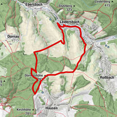
Die orangene Strecke ist eine Verlängerung der roten Strecke.

Arviointi
Tekniikka
Kunto
Maisema
Elämys
Paras kausi
tammi
helmi
maalis
huhti
touko
kesä
heinä
elo
syys
loka
marras
joulu
Korkein kohta
235 m
Kohde

Parkplatz Lourdesgrotte Niedernberg

Korkeusprofiili
© outdooractive.com

Kirjoittaja

Yleinen luokitus

5

0

%

4

0

%

3

0

%

2

0

%

1

0

%

Virhe
On tapahtunut virhe. Yritä uudelleen.
Kiitos arvostelusta

Luokitus poistettiin

GPS Downloads
  • GPX GPS Exchange Format (XML)
  • KML Google Earth, Google Maps
QR-latauskoodit matkapuhelimiin
Lisää retkiä alueilla

Suosittuja retkiä alueella

Leidersbach - "Blaue Tour" - Nordic Walking

helppo Nordic Walking
6,16km | 132hm | 01:28h

Müllers Wandertouren "Rote Nordic Walking" Strecke

Nordic Walking
10,9km | 196hm | 02:31h

Leidersbach - "Rote Tour" - Nordic Walking

tapa Nordic Walking
10,28km | 179hm | 02:22h

Leidersbach - "Schwarze Tour" - Nordic Walking

tapa Nordic Walking
11,69km | 281hm | 02:46h