Rundkurs Wörthsee - von Inning am Ammersee, Bayern

Logo Rundkurs Wörthsee - von Inning am Ammersee, Bayern
Retkitiedot
16,36km
506 - 579m
Distanz
27hm
44hm
Nousu
01:33h
 
Kesto
Lyhyt kuvaus

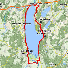
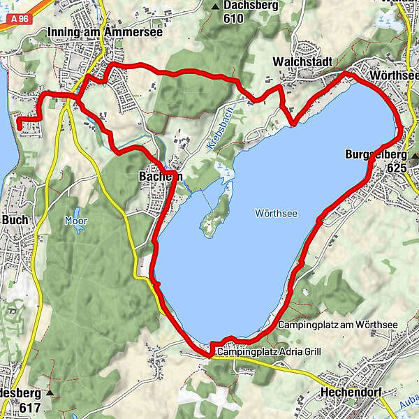
Radtour rund um Wörthsee. Ausgangspunkt Inning Parkplatz

Vaikeus
helppo
Arviointi
Tekniikka
Kunto
Maisema
Elämys
Reitti
Schorn
0,2 km
Inning am Ammersee
1,8 km
Walchstadt
4,1 km
Wörthsee
6,1 km
Seehaus Raabe
6,2 km
Augustiner am Wörthsee
6,6 km
Steinebach am Wörthsee
7,3 km
Adria Grill
10,6 km
Bachern
13,2 km
Schorn
16,0 km

Paras kausi
tammi
helmi
maalis
huhti
touko
kesä
heinä
elo
syys
loka
marras
joulu
Korkein kohta
579 m

Lähde
Stefan

Yleinen luokitus

5

0

%

4

0

%

3

0

%

2

0

%

1

0

%

Virhe
On tapahtunut virhe. Yritä uudelleen.
Kiitos arvostelusta

Luokitus poistettiin

GPS Downloads
  • GPX GPS Exchange Format (XML)
  • KML Google Earth, Google Maps
QR-latauskoodit matkapuhelimiin

Ajoreitit

Asfaltti
Sora
Metsä
Vuoripolut
Singletrails
Trial
Liikenne
Lisää retkiä alueilla

Suosittuja retkiä alueella

Radweg um den Ammersee

helppo
47,49km | 140hm | 03:30h

Die drei kleinen Seen

17,94km | 151hm | 01:20h

Radweg um den Starnberger See

49,8km | 179hm | 04:00h