© Unbekannt - schwarz-koenig.at
- Lyhyt kuvaus
-
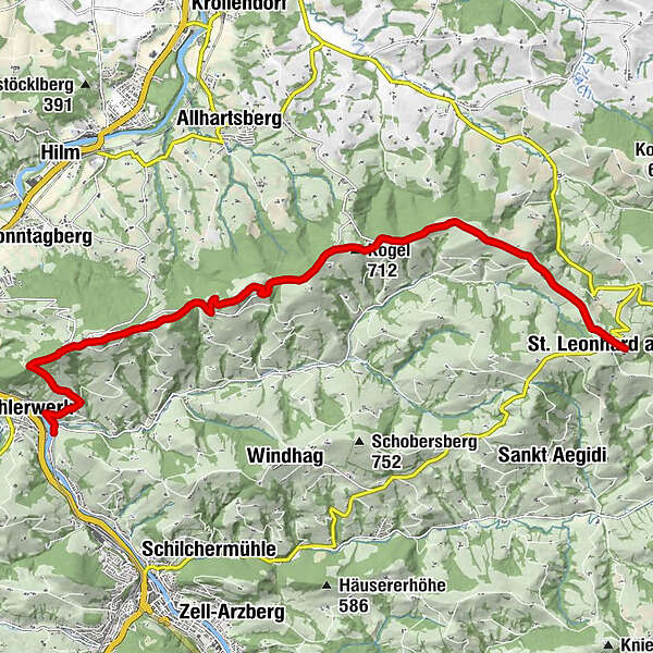
The tour with a beautiful panoramic view over the Mostviertel leads past the Basilica on the Sonntagberg. The tour leads from Waidhofen/Ybbs to St. Leonhard / Walde. The 600 altitude meters are easy to deal with.
- Vaikeus
-
tapa
- Arviointi
-
- Reitti
-
Gasthof Kerschbaumer0,1 kmBöhlerwerk0,3 kmWühr2,5 kmDreifaltigkeitskapelle2,9 kmSonntagberg3,0 kmWallfahrtskirche zur Heiligen Dreifaltigkeit und zum hl. Michael3,1 kmBrunnenkluft3,2 kmSonntagberg (716 m)3,2 kmReisenberg3,6 kmKogel (712 m)8,1 kmGasthof & Konditorei Fam. Ettel13,1 kmLeonhardihof13,1 kmPfarrkirche St. Leonhard13,1 kmSt. Leonhard am Wald13,3 km
- Paras kausi
-
tammihelmimaalishuhtitoukokesäheinäelosyyslokamarrasjoulu
- Korkein kohta
- 720 m
- Kohde
-
St. Leonhard/Walde
- Korkeusprofiili
-

- Kirjoittaja
-
Kiertue Waidhofen - Sonntagberg - St. Leonhard_Walde käyttää outdooractive.com toimitettu.
GPS Downloads


Yleistä tietoa
Virvokepysäkki
Lupaava
Lisää retkiä alueilla
-
Mostviertel
2453
-
Melker Alpenvorland
797
-
Allhartsberg
172