Talvi
Kesä
Sää
Webbikamerat
Majoitukset
Retket
Hakuhistoria
Hakuehdotukset
Tuloksia ei löytynyt
Etsi
Retket
Etusivu
Kesä Österreich
Ala-Itävalta
Retket
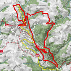
Rundwanderweg: Mostviertler Rundwanderweg 254/454
Alueet
Sää
Webbikamerat
Retket
Highlights
Uimajärvet
Majoitukset
Tarjoukset
Urheilutoimittaja
Tapahtumat
Hiihtoalueet
Hiihto
Lumipuistot
Rundwanderweg: Mostviertler Rundwanderweg 254/454
Kirjanmerkki
Kartta
näytä
piilota
Tulosta
Retkitiedot
136,4
km
227 - 745
m
Distanz
3.019
hm
3.064
hm
Nousu
10:08
h
Kesto
gtwo
laadittu am 22.05.2014
2 537
Puhelut
Arviointi
Tekniikka
Kunto
Maisema
Elämys
Korkein kohta
745 m
2,7
Kirjoita arvostelu
Yleinen luokitus
5
0
%
4
33
%
3
33
%
2
0
%
1
33
%
Arviot
2,7
(3)
0 Kommentit
Kirjoita arvostelu
Virhe
On tapahtunut virhe. Yritä uudelleen.
Kiitos arvostelusta
Luokitus poistettiin
Kiertueen raportti
GPS Downloads
GPX
GPS Exchange Format (XML)
KML
Google Earth, Google Maps
QR-latauskoodit matkapuhelimiin
Rundwanderweg: Mostviertler Rundwanderweg 254/454
QR-koodit - Tour lataa matkapuhelimiin
GPX
KML
Lisää retkiä alueilla
Traunviertel
1940
Moststraße
754
Aschbach-Markt
98
Suosittuja retkiä alueella
Kreuzner Heartbeat-circuit-Our favourite spot
tapa
10,35
km |
271
hm |
03:05
h
Lindaumauer (1103 m)
3,4
km |
277
hm |
01:30
h
Auf den Prochenberg
tapa
12,04
km |
680
hm |
03:30
h
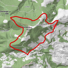
Rundweg Glasenberg E33
helppo
6,48
km |
225
hm |
02:30
h
Merkintöjä ei löytynyt.
Haku ei ole tällä hetkellä käytettävissä.
Tarkenna hakua.
Paikalliset hakutulokset
(<= 25km)
Lisää hakutuloksia
(> 25km)
%count% Hakutulokset
%name%
%type%
%elevation%
%population%
%lpButton%