Retkitiedot
4,26km
412 - 553m
Distanz
116hm
5hm
Nousu
01:11h
 
Kesto
Lyhyt kuvaus

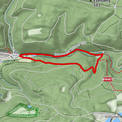
Winterwanderweg durch das Grumbachtal in Wildemann.

Vaikeus
tapa
Arviointi
Tekniikka
Kunto
Maisema
Elämys

Paras kausi
elo
syys
loka
marras
joulu
tammi
helmi
maalis
huhti
touko
kesä
heinä
Korkein kohta
553 m
Kohde

Grumbacher Teich oder Hahnenklee, Kuttelbacher Teich

Korkeusprofiili
© outdooractive.com

Kirjoittaja
Kiertue Wanderweg Grumbachtal käyttää outdooractive.com toimitettu.

5,0
Yleinen luokitus

5

100

%

4

0

%

3

0

%

2

0

%

1

0

%

GPS Downloads
  • GPX GPS Exchange Format (XML)
  • KML Google Earth, Google Maps
QR-latauskoodit matkapuhelimiin
Lisää retkiä alueilla

Suosittuja retkiä alueella

Wellner Weg-Schwarzenberg

tapa
5,01km | 117hm | 01:26h

Schalker Grabenweg

helppo
1,53km | 12hm | 00:24h

Rehberger Graben zum Oderteich

helppo
6,86km | 95hm | 01:45h

Wanderweg durch das Spiegeltal

tapa
3,72km | 108hm | 01:05h