- Lyhyt kuvaus
-
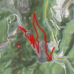
It's a long climb of 15.7 km with 1170 m of D+ at... 7.5%! A figure that means you'll have to make a big effort. In fact, the gradient doesn't drop below 7%, rising to 8.5% for the final stretch (1.3 km)!
- Vaikeus
-
vaikea
- Arviointi
-
- Reitti
-
San Salvatore0,5 kmRorà2,8 kmWaterfall7,0 kmRobione10,0 kmChapelle Saint-Sébastien10,4 kmVillars12,9 kmLes Vautes13,1 kmAuberge Quintessence15,8 km
- Paras kausi
-
tammihelmimaalishuhtitoukokesäheinäelosyyslokamarrasjoulu
- Korkein kohta
- 1.675 m
- Kohde
-
On the signpost at the top of the pass, next to the commemorative stele
- Korkeusprofiili
-
 © outdooractive.com

-

-
KirjoittajaKiertue Climbing the Col de la Couillole käyttää outdooractive.com toimitettu.
GPS Downloads


Yleistä tietoa
Virvokepysäkki
Flora
Lupaava
Lisää retkiä alueilla
-
Alpes-Maritimes
71
-
Alpes d'Azur
33