Retkitiedot
11,31km
433
- 439m
12hm
7hm
02:50h
- Lyhyt kuvaus
-
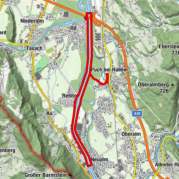
Wanderung vom Zentrum in Puch zur Salzach. Vorerst orogr. rechts flussaufwärts bis auf Höhe der Brauerei Kaltenhausen und anschließend orogr. links flussabwärts bis zum Kraftwerk Urstein. Nach neuerlichem Übersetzen der Uferseite Fluß aufwärts bis zum Ausgangspunkt. Der Wanderweg eignet sich auch sehr gut als Laufstrecke.
- Vaikeus
-
helppo
- Arviointi
-
- Lähtöpiste
-
Öffentlicher Parkplatz im Zentrum von Puch (neben Gemeindeamt) (438 m)
- Reitti
-
Puch bei Hallein0,0 kmKapelle0,1 kmNeualm3,2 kmHallein3,4 kmRehhof5,3 kmRifer Spitz7,8 kmPuch bei Hallein10,8 kmKapelle11,2 km
- Paras kausi
-
tammihelmimaalishuhtitoukokesäheinäelosyyslokamarrasjoulu
- Korkein kohta
- 439 m
- Kohde
-
Öffentlicher Parkplatz im Zentrum von Puch (neben Gemeindeamt)
- Infopuhelin
-
+43 (0)6463 7488
- Link
- http://www.stmartin.info/
- Lähde
- bergfexsport / Gästeservice Tennengau
GPS Downloads


Polun olosuhteet
Asfaltti
Sora
Niitty
Metsä
Kallio
Altistettu
Lisää retkiä alueilla