
Retkitiedot
4,08km
443
- 540m
92hm
26hm
01:15h
- Lyhyt kuvaus
-
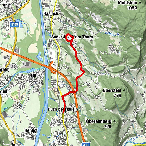
Wanderweg vom Ortszentrum Puch in den hübschen Ort St. Jakob am Thurn. Dort ist der kurze Rundweg um den See zu empfehlen. Einen Teil dieser Strecke bildet der Rosenkranzweg mit mehreren Stationen.
- Vaikeus
-
helppo
- Arviointi
-
- Lähtöpiste
-
Öffentlicher Parkplatz neben dem Gemeindeamt
- Reitti
-
Puch bei HalleinGasthof Kirchenwirt0,0 kmPfarrkirche Puch bei Hallein0,0 kmPuch0,1 kmSt. Jakob am Thurn3,0 kmSankt Jakob am Thurn3,1 kmSchützenwirt3,7 km
- Paras kausi
-
tammihelmimaalishuhtitoukokesäheinäelosyyslokamarrasjoulu
- Korkein kohta
- 540 m
- Kohde
-
Öffentlicher Parkplatz neben dem Gemeindeamt
- Lepo/Retriitti
-
Einkehrmöglichkeiten am Ausgangs- bzw. Endpunkt beim Kirchenwirt oder in St. Jakob beim Schützenwirt.
- Infopuhelin
-
+43 (0)6463 7488
- Link
- http://www.stmartin.info/
- Lähde
- bergfexsport / Gästeservice Tennengau
GPS Downloads


Polun olosuhteet
Asfaltti
Sora
Niitty
Metsä
Kallio
Altistettu
Lisää retkiä alueilla


