© Unbekannt - Stummer

© kunsthaus muerz - Johannes Ganster

© Erlebnisregion Hochsteiermark


- Lyhyt kuvaus
-
Stage 9 - at a glance:
Start: Mürzzuschlag, tourist information, overnight accommodations: Tel.: +43 3852 3399, www.waldheimat-steirischersemmering.at
Cab services: Mürz Taxi Schwarz Tel.: +43 3852 6070, Taxi Ellmeier / Naturparktaxi Tel.: +43 3852 30303
GPS grid N 47° 36' 24,4" E 15° 40' 18,7"Destination / overnight stop: Rosegger Schutzhaus on the Pretul, Tel.: +43 3170 522, www.ratten.naturfreunde.at
GPS grid N 47° 32' 46,0" O 15° 44' 22,8"
Stage length: 21.8 kilometers
Total walking time (without breaks): 8 hours
Meters of ascent: 1,300 meters of ascent
Meters of altitude descent: 385 meters of altitude
Difficulties: long but easy valley and mountain hike
- Vaikeus
-
vaikea
- Arviointi
-
- Reitti
-
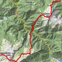
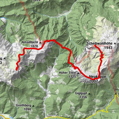
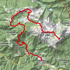
Mürzzuschlag0,1 kmMürzzuschlag0,3 kmGasthaus Edlacherhof2,8 kmEdlach2,9 kmGrautschenhof4,7 kmGasthaus Familie Kratzer7,5 kmSpital am Semmering7,9 kmPichl8,0 kmHocheck (1.488 m)12,6 kmQuelle von A.G.H.14,7 kmStuhleck (1.782 m)15,5 kmAlois-Günther-Haus15,6 kmGrazer Stuhleck (1.635 m)18,4 kmGeiereck (1.644 m)18,9 kmPretul (1.656 m)20,1 kmRoseggerhaus20,8 km
- Paras kausi
-
tammihelmimaalishuhtitoukokesäheinäelosyyslokamarrasjoulu
- Korkein kohta
- 1.775 m
- Kohde
-
Rosegger Schutzhaus auf der Pretul
- Korkeusprofiili
-


- Kirjoittaja
-
Kiertue Etappe 09: BergZeitReise Mürzzuschlag - Stuhleck - Pretul käyttää outdooractive.com toimitettu.
GPS Downloads


Yleistä tietoa
Virvokepysäkki
Kulttuuri/Historiallinen
Lupaava
Lisää retkiä alueilla
-
Hochsteiermark
4082
-
Waldheimat
2196
-
Spital am Semmering / Stuhleck
786