

- Lyhyt kuvaus
-
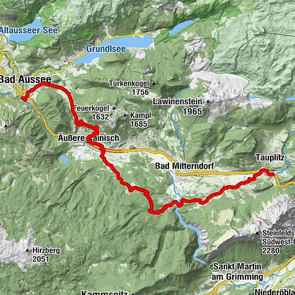
This tour throughout the region with its unique landscape from west to east will lead you from Bad Aussee to Tauplitz. At the end you will pass a highlight: The skiflying hill at the Kulm between Bad Mitterndorf and Tauplitz.
- Vaikeus
-
tapa
- Arviointi
-
- Reitti
-
Sportstüberl, PizzeriaUnterkainisch0,4 kmEselsbach0,8 kmBad Aussee (659 m)1,2 kmAnger2,1 kmFilialkirche hl. Leonhard2,2 kmAlmwirt3,7 kmGschlößl5,0 kmRadling6,0 kmLenzbaueralm7,5 kmKranawetta9,9 kmÄußere Kainisch10,2 kmPichl11,2 kmMühlreith12,8 kmFurt29,8 kmTauplitz (835 m)30,3 kmGasthof Moser30,5 kmSchrödis30,6 km
- Paras kausi
-
tammihelmimaalishuhtitoukokesäheinäelosyyslokamarrasjoulu
- Korkein kohta
- 1.004 m
- Kohde
-
Railway station in Tauplitz
- Korkeusprofiili
-


- Kirjoittaja
-
Kiertue From Bad Aussee to Tauplitz käyttää outdooractive.com toimitettu.
GPS Downloads


Yleistä tietoa
Virvokepysäkki
Lupaava
Lisää retkiä alueilla


