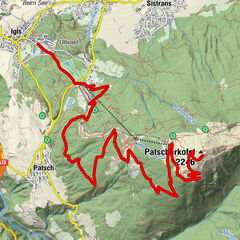
Sistrans - Sistranser Alm

Logo Sistrans - Sistranser Alm
Retkitiedot
8,83km
988 - 1.611m
Distanz
623hm
609hm
Nousu
00:51h
 
Kesto
Lyhyt kuvaus

Kontinuierliche Steigung - mit Ebike easy zu fahren

Vaikeus
helppo
Arviointi
Tekniikka
Kunto
Maisema
Elämys
Reitti
Sistrans (919 m)
Unterer Berg
0,4 km
Sistranser Alm (1.609 m)
4,3 km
Unterer Berg
8,3 km
Sistrans (919 m)
8,8 km

Korkein kohta
1.611 m

Yleinen luokitus

5

0

%

4

0

%

3

0

%

2

0

%

1

0

%

Virhe
On tapahtunut virhe. Yritä uudelleen.
Kiitos arvostelusta

Luokitus poistettiin

GPS Downloads
  • GPX GPS Exchange Format (XML)
  • KML Google Earth, Google Maps
QR-latauskoodit matkapuhelimiin
Lisää retkiä alueilla

Suosittuja retkiä alueella

Innsbruck/ Igls: Patscherkofel

Mountainbike
14,13km | 1469hm | 03:30h

Tulfeinalm

tapa Mountainbike
10,03km | 740hm | 03:15h

Stanser Joch - anstrengend aber lohnend!

vaikea Mountainbike
13,09km | 1209hm | 04:00h

Vomp: Hinterhorn-, Walder-, und Ganalm

Mountainbike
27,56km | 930hm | 02:30h