Road bike 17 Highway to Hell - retracing the 2018 Road World Championships routes


- Lyhyt kuvaus
-
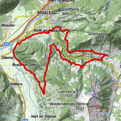
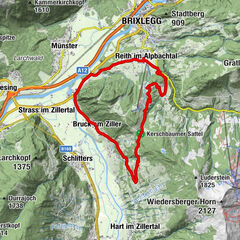
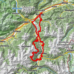
This is a very hard tour retracing the 2018 Road World Championships routes. The highlight of the tour is the steepness of the "Höll" (translated "Hell"), which has a gradient of 25%. You need really strong legs for this stretch.
- Vaikeus
-
vaikea
- Arviointi
-
- Reitti
-
Rattenberg0,0 kmAmerling1,5 kmKramsach1,5 kmBrixlegg2,5 kmHagau (517 m)2,6 kmPizzeria Buongiorno5,5 kmMünster (535 m)6,3 kmEntgasse6,7 kmHaus7,6 kmBradl8,5 kmBus-Stop9,6 kmDorfwirt9,9 kmWiesing9,9 kmVeitenkapelle12,6 kmEvang. Erlöserkirche13,2 kmJenbach (563 m)13,4 kmHupfaufkapelle14,4 kmTratzberg16,0 kmFriedhofskapelle18,7 kmGasthof Marschall18,9 kmStans18,9 kmSchwaz21,7 kmVomp23,0 kmGasthaus Pelikan23,0 kmVomperbach25,3 kmTerfens28,0 kmPfarrkirche Sankt Juliana28,0 kmNeu-Terfens28,7 kmNeuterfens28,7 kmFritzens-Wattens32,8 kmFritzens (591 m)32,8 kmWattens (564 m)32,8 kmBaumkirchen (593 m)35,1 kmPfarrkirche Baumkirchen35,1 kmAnnakapelle35,5 kmLourdeskapelle37,4 kmPfarrkirche Mils38,1 kmmilsano38,2 kmGasthof Tiefenthaler38,2 kmMils (605 m)38,5 kmFranziskuskirche38,8 kmKaiser Franz Josef-Gedächtniskapelle40,1 kmHall in Tirol (574 m)40,1 kmAbsam (632 m)41,9 kmAntoniuskapelle43,7 kmThaur (633 m)44,1 kmRum (621 m)45,7 kmMarienkapelle45,9 kmRistorante-Pizzeria Amici47,7 kmArzl48,1 kmSternbachkapelle49,4 kmRosengarten49,4 kmMühlau49,5 kmSt. Nikolaus51,4 kmSt. Nikolaus52,0 kmHöttinger Kirche52,2 kmHöttinger Pestfriedhof52,5 kmÖlbergkapelle54,1 kmSteinbruchkurve54,5 kmPischelkurve54,9 kmHungerburg55,6 kmHungerburg (857 m)55,9 kmTheresienkirche56,2 kmKatzenbrunnenquelle57,3 kmGasthaus Gramart57,6 kmHöll58,1 kmHötting59,6 kmKapelle Maria Hilf60,0 kmMariahilf60,1 kmAltstadt60,1 kmInnsbruck (574 m)60,1 kmSt. Nikolaus60,5 kmMühlau62,5 kmRosengarten62,6 kmSternbachkapelle62,7 kmArzl64,1 kmRistorante-Pizzeria Amici64,4 kmMarienkapelle66,2 kmRum (621 m)66,2 kmThaur (633 m)67,8 kmAntoniuskapelle68,1 kmAbsam (632 m)70,2 kmHall in Tirol (574 m)70,6 kmLa Taverna71,1 kmPfarrkirche Eichat71,5 kmSchmankerlstock72,0 kmNepomukkapelle72,5 kmWalderkapelle73,5 kmSt. Martin75,9 kmAußerwald76,4 kmSpeckbacherkapelle76,6 kmGnadenwald (879 m)76,7 kmSt. Michael77,3 kmKranzach78,3 kmBrantach79,1 kmMairbach79,9 kmSchlögelsbach81,0 kmTerfens83,1 kmStoanergroben85,7 kmVomperbach85,8 kmPill (556 m)86,9 kmKreuzkirchl87,9 kmSchwaz90,3 kmBuch in Tirol94,9 kmJenbach (563 m)97,4 kmMaurach97,6 kmGasthof Cafe Zillertal102,0 kmGrillalm102,0 kmStrass im Zillertal (523 m)102,0 kmFilialkirche St. Gertraudi104,4 kmSankt Gertraudi (527 m)104,6 kmLichtwerth (529 m)105,8 kmRestaurant Gut Matzen106,4 kmWeng (526 m)107,2 kmBrixlegg107,8 kmRattenberg109,8 km
- Paras kausi
-
tammihelmimaalishuhtitoukokesäheinäelosyyslokamarrasjoulu
- Korkein kohta
- 894 m
- Kohde
-
Rattenberg, town main square fountain
- Korkeusprofiili
-


-

-
KirjoittajaKiertue Road bike 17 Highway to Hell - retracing the 2018 Road World Championships routes käyttää outdooractive.com toimitettu.
GPS Downloads


Yleistä tietoa
Virvokepysäkki
Lupaava
Lisää retkiä alueilla