
Retkitiedot
14,9km
794
- 1.829m
1.035hm
06:00h
- Lyhyt kuvaus
-
Wanderung auf einen der schönsten Aussichtsberge Tirols
- Vaikeus
-
tapa
- Arviointi
-
- Lähtöpiste
-
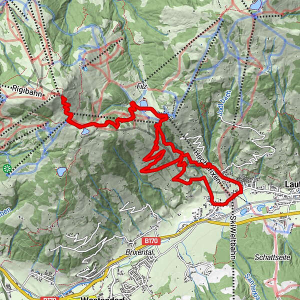
Parkplatz der Bergbahn Hochbrixen - Brixen im Thale
- Reitti
-
Sonnenlift0,0 kmBrixen im Thale0,1 kmFilzalm3,6 kmFoischingbahn (1.641 m)5,1 kmGipfelalm Hohe Salve5,8 kmHohe Salve (1.829 m)5,8 kmWallfahrtskirche Hohe Salve5,9 kmFilzalm8,4 kmSonnberg10,8 kmHof13,7 kmBrixen im Thale14,3 km
- Paras kausi
-
tammihelmimaalishuhtitoukokesäheinäelosyyslokamarrasjoulu
- Korkein kohta
- 1.829 m
- Kohde
-
Hohe Salve - einer der schönsten Aussichtsberge Tirols
- Lepo/Retriitti
-
Berggasthof Nieding, Panoramarestaurant Hohe Salve
- Karttamateriaali
-
Wanderkarten können Sie in allen Tourismusbüros der Region erwerben
- Infopuhelin
-
+43 (0)5357 2000-200
- Link
- http://www.hohe-salve.at
- Lähde
- Kitzbüheler Alpen - Brixental
GPS Downloads


Polun olosuhteet
Asfaltti
Sora
Niitty
Metsä
Kallio
Altistettu
Lisää retkiä alueilla
-
Kitzbüheler Alpen - Brixental
1772
-
Westendorf
452


