© Alpenregion Bludenz Tourismus GmbH - Klaus Allgäuer
- Lyhyt kuvaus
-
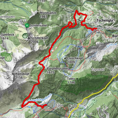
On this winter hiking trail from the Tschengla high plateau via the Burtscha Alpe up to the Burtschasattel, you will be rewarded with breathtaking views of the Zimba and the Alpine town of Bludenz!
- Vaikeus
-
helppo
- Arviointi
-
- Reitti
-
Fuchsbau2,2 kmBurtschaalpe3,0 kmFrööd5,3 kmBurtschaalpe7,5 kmFuchsbau8,4 km
- Paras kausi
-
elosyyslokamarrasjoulutammihelmimaalishuhtitoukokesäheinä
- Korkein kohta
- 1.665 m
- Kohde
-
Car park Tschengla, Bürserberg
- Korkeusprofiili
-

- Kirjoittaja
-
Kiertue Burtschaweg | Bürserberg käyttää outdooractive.com toimitettu.
GPS Downloads


Yleistä tietoa
Virvokepysäkki
Lupaava
Lisää retkiä alueilla
-
Appenzellerland
94
-
Brandnertal
152
-
Brand
36