© Unbekannt - Zermatt Tourismus

© Unbekannt - Zermatt Tourismus

© © matterhorn.ultraks.com /J. Saragossa - Zermatt Tourismus
© Matterhorn Ultraks - Zermatt Tourismus
© Matterhorn Ultraks


- Lyhyt kuvaus
-
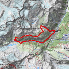
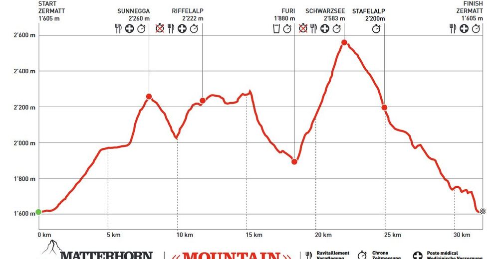
This course demands a great deal of effort, even though endurance athletes regard it as “medium” distance. Runners cover a total of 32 km, with ascents and descents of 2,000 vertical metres.
- Vaikeus
-
tapa
- Arviointi
-
- Reitti
-
Zermatt (1.608 m)0,0 kmKirche St. Mauritius0,4 kmOthmar’s Skihütte3,5 kmSunegga (2.277 m)7,8 kmEggen (2.177 m)8,9 kmZe Gassen (2.051 m)9,6 kmRiffelalp (2.222 m)13,3 kmFuri18,5 kmSchwarzsee paradise22,2 kmSchwarzsee (2.588 m)22,2 kmStafelalp25,0 kmStafel (2.139 m)25,3 kmBiel25,7 kmZmutt27,7 kmZermatt (1.608 m)31,9 km
- Paras kausi
-
tammihelmimaalishuhtitoukokesäheinäelosyyslokamarrasjoulu
- Korkein kohta
- 2.580 m
- Kohde
-
Zermatt (1,620 m)
- Korkeusprofiili
-
 © outdooractive.com


- Kirjoittaja
-
Kiertue Matterhorn Ultraks Trail "Mountain" käyttää outdooractive.com toimitettu.
GPS Downloads


Yleistä tietoa
Virvokepysäkki
Flora
Fauna
Lupaava
Lisää retkiä alueilla
-
Unterwallis
74
-
Mattertal
34
-
Zermatt
14