


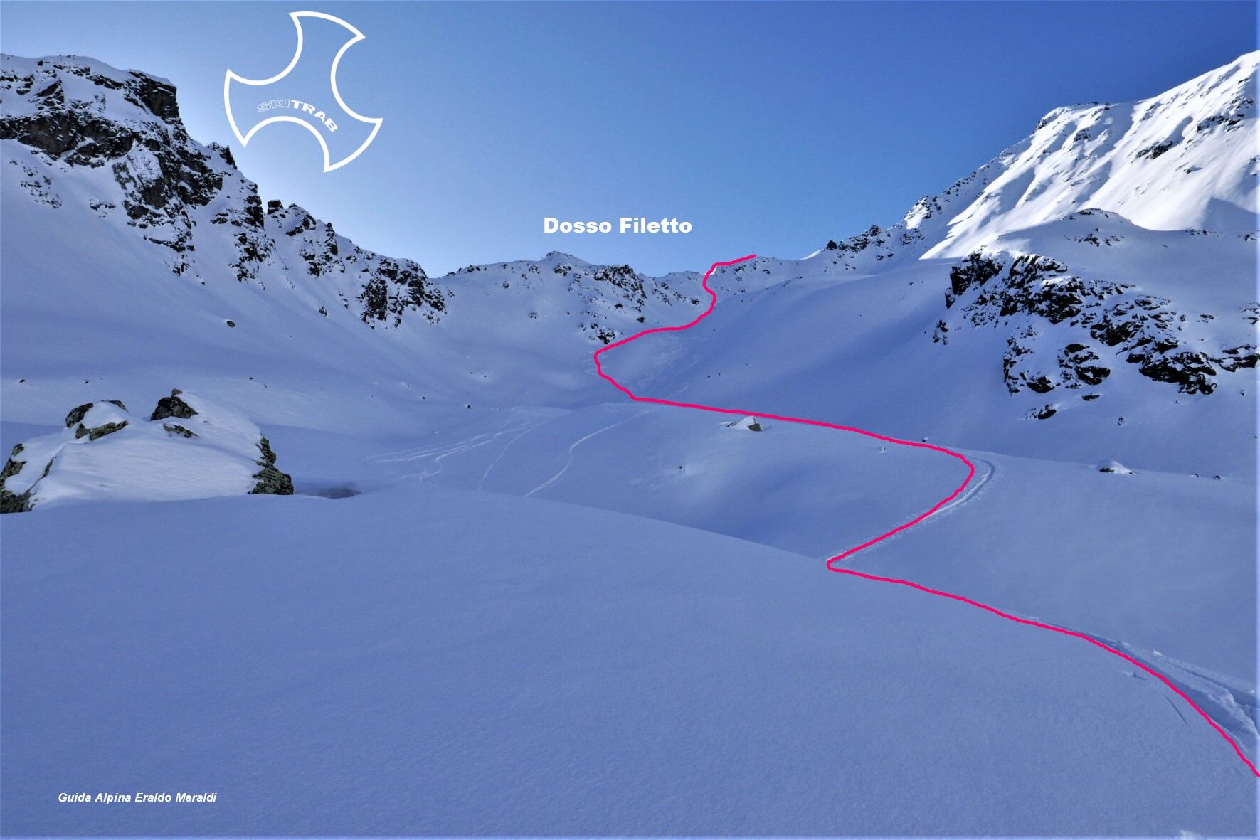
Dosso Filetto


From Monte you climb, following the small road that leads to the Campacciolo locality, passing by the Campello and Campello Alto huts. Then you enter the Campacciolo valley and come close to the lake of...
From Monte you climb, following the small road that leads to the Campacciolo locality, passing by the Campello and Campello Alto huts. Then you enter the Campacciolo valley and come close to the lake of the same name after passing a steep section. At this point you bend sharply to the left and follow a series of obvious little valleys that lead to the final amphitheater, which you go up along a steep gully to the ridge and a little to the right to the high point. Descent along the ascent route.

Tresenda, Baitel Grasso degli Agnelli, Pizzo Filone.
Self-rescue equipment (ARTVA, shovel and probe). Rampant.
The route description and trail are approximate and should be verified on site depending on the condition of the snowpack present during the hike.
Because this is a hike in a snowy mountain environment at high altitudes subject to continually changing snowpack conditions, it is advisable to have adequate experience in ski mountaineering, knowledge of the area, and up-to-date information on snow conditions.
Accompaniment with a professional guide is recommended.
Before entering the village.
The route description and trail are approximate and should be verified on site depending on the condition of the snowpack present during the hike.
Because this is a hike in a snowy mountain environment at high altitudes subject to continually changing snowpack conditions, it is advisable to have adequate experience in ski mountaineering, knowledge of the area, and up-to-date information on snow conditions.
Accompaniment with a professional guide is recommended.
Suosittuja retkiä naapurustossa
-
4,5
Stelvio Epic Rides: Stelvio Pass
raskasMaantiepyörä 20,9 km -
Stelvio Epic Rides: Gavia Pass
raskasMaantiepyörä 25,8 km -
5,0
Energy2Run Cancano
mediumPolkujuoksu 19,1 km -
5,0
Niblogo/ rifugio V alpini
mediumVaellus 13,3 km -
5,0
Mount Staircase Ring
mediumVaellus 7,53 km -
Cancano Lakes Tour
mediumVaellus 19,3 km -
Val da Camp (724)
mediumVaellus 5,33 km -
Piz Cunfin , Poschiavo, Oberengadin
mediumVaellus 26,9 km -
Hiking in the Rezzalo Valley from the Alpe Bridge
raskasVaellus 12,3 km -
Stelvio Historical Trek: Solena - Forcola di Rims
mediumVaellus 20,2 km
Vaellus & jäljitys


Älä jää paitsi tarjouksista ja inspiraatiosta seuraavaa lomaasi varten.
Sähköpostiosoitteesi on lisätty postituslistalle.